| This is the original running route prepared for the
"Serpentine Running Club: Route 18: The Monopoly Run" as originally
devised by Nick Slade in 2004 and is reproduced with permission |
w.jpg) |
| Copyright 2004 Nick Slade (map and
directions) |
 |
|
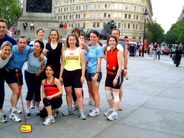
Nick Slade organised
3 small fun races over the course (2004,2005 & 2006) involving 6
teams (Dogs,Boats etc).
Above
is "DOG" team of 2004 .. Nick is the one in the light blue
being held down by team mates. The "dog" is just visible in his
bag. |
|
DISTANCE (MILES) |
DESCRIPTION |
MONOPOLY LOCATION |
RA REF |
|
0 |
The Seymour Centre is the allocated position for "GO!" .
Head south along Seymour Place |
GO! |
11A |
|
0.3 |
At end of Seymour Place turn right then immediately left
into Edgware Road .Carry on down left hand side of road |
|
|
0.4 |
Just before end of Edgware Road go down ramp into subway
, turning first right , then first left, passed the
public conveniences to end , then left up ramp and pass
through gate into Speakers Corner. |
|
|
0.5 |
Take third turning on right onto main cycleway and
follow towards Hyde Park Corner |
|
100A |
|
0.7 |
Take left fork towards fountain. Just beyond fountain
exit the park onto Park Lane . Nearby is a subway
entrance. |
|
|
0.9 |
Go down into subway make way to opposite side of Park
Lane. On exit of subway, head north (to the right) along
Park Lane for around 100m |
|
|
1.0 |
You are now at The Grosvenor Hotel , the allocated stop
for PARK LANE. From the entrance to the Grosvenor Hotel
, go back south along Park lane and take the first left
turn , heading down Mount Street. Follow Mount street
until it reaches its end, turn right into Berkeley
Square. |
PARK LANE |
|
1.5 |
The Centre of Berkeley square is the allocated stop for
MAYFAIR. Exit Berkeley square via Bruton Street on the
opposite side of the square to where you entered. Follow
Bruton street for approx 200m before turning left into
New Bond Street . Follow New Bond Street to Sotheby's on
the RHS of the road. |
MAYFAIR |
|
1.7 |
Sotheby's is the allocated stop for BOND STREET. From
here continue along road in the same direction for
around 400m until you reach Oxford Street. Turn right
into Oxford Street and head towards John Lewis. Don�t
worry about Crossing road, but remain on the RHS path. |
BOND STREET |
|
2.1 |
The location on the opposite side of the road to John
Lewis is the allocated stop for OXFORD STREET. Continue
down the RHS path , and take the first right down
Harewood Place and left following the perimeter of
Hanover Square to Hanover Street. Turn right into
Regents Street and cross to opposite side (LHS) . Follow
Regents Street to Great Marlborough Street on the left.
Turn into Great Marlborough Street and after just a few
metres you will reach the entrance to "Liberty's"
department store. |
OXFORD STREET |
|
2.5 |
Liberty's is the Allocated stop for MARLBOROUGH STREET .
At entrance to Liberties turn right down Kingly Street
and follow to end. Turn right then first left into
Warwick Street and follow to end. Turn right into
Glasshouse street and the left into Regents Street.
Follow Regents street as far as the Caf� Royal on the
LHS of the road. |
MARLBOROUGH STREET |
|
2.9 |
The Caf� Royal is the allocated stop for REGENTS STREET.
From here go back the way you came along Regents Street
(to your right as you look towards the road from the
Caf� Royal) and cross over road to LHS. Follow road and
take first left into Swallow Street. Follow Swallow
Street as it curves to the left and a short way down you
will find vine street on your left. |
REGENTS STREET |
|
3.0 |
Vine Street, being so small , is in fact the allocated
stop for VINE STREET . There is unfortunately not much
there. From here , continue in the same direction along
Swallow Street until it ends at Piccadilly. Cross
Piccadilly at nearby crossing and turn left , following
road to Piccadilly circus. Once in Piccadilly circus use
appropriate crossings to get to the statue of Eros in
the middle. |
VINE STREET |
|
3.2 |
Eros is the allocated stop for PICCADILLY CIRCUS . From
here head in more or less the same direction for another
50m and you will see the Trocadero on the opposite LHS
of the road. Don�t worry about Crossing road, but remain
on the RHS path. |
PICCADILLY CIRCUS |
100B |
|
3.3 |
The location on the opposite side of the road to the
Trocadero is the allocated stop for COVENTRY STREET.
From here turn right into the Haymarket and follow for
around 300m to its end at the junction with Pall Mall. |
COVENTRY STREET |
|
3.5 |
On the junction of Haymarket and Pall Mall there is the
New Zealand Travel centre and a big sign for Pall Mall
on the wall . The Road sign is the allocated stop for
PALL MALL. From here turn left and follow road to
Trafalgar Square. Use appropriate crossing points to get
to Nelsons Column in the middle of the Square |
PALL MALL |
|
3.7 |
Nelsons Column is the allocated stop for TRAFALGAR
SQUARE. Exit Trafalgar square via Whitehall and follow
Whitehall on the RHS of the road. About 200m down the
road are the Admiralty Buildings. |
TRAFALGAR SQUARE |
|
3.8 |
The Admiralty Buildings are the allocated stop for
WHITEHALL. Cross the road and on the opposite side there
is the entrance to Great Scotland Yard. Follow Great
Scotland Yard until it's end at Northumberland Street.
Almost opposite the exit to Great Scotland Yard on
Northumberland Avenue is a pub called the "Sherlock
Holmes" . Cross over Northumberland Avenue and head
towards this pub. |
WHITEHALL |
|
4.0 |
The "Sherlock Holmes" pub is the allocated stop for
NORTHUMBERLAND AVENUE. From here take Right Hand fork
along Northumberland Street, heading straight on (road
veers to the right, pedestrian zone goes straight on) as
far as The Strand. Turn left towards Trafalgar square
and cross over the road following the perimeter or
Trafalgar square Past South Africa House to St Martins
Place. Follow St Martins Place, then take a left into
Irving Street. Follow Irving Street until it opens out
into Leicester Square. |
NORTHUMBERLAND AVENUE |
|
4.4 |
The Odeon cinema is the allocated stop for LEICESTER
SQUARE. From here exit head to the right (right as you
face the square from the Odeon Entrance ) and exit the
square via Cranbourn Street on the right. Follow
Cranbourn Street across major junction with Charring
Cross Road as far as a 6 way junction of roads .Take a
right turn into Garrick Street and follow this as it
turns left into Kings Street and alongside Covent Garden
Market. Continue straight on (Market is on your RHS)
through the Plaza and follow the road as it goes Right .
Take the next left into Russell Street and left again
into Bow Street. Just round the corner is the entrance
to the Royal Opera House. |
LEICESTER SQUARE |
|
4.9 |
The Royal Opera House is the allocated stop for BOW
STREET. Head back down Bow Street (to the right as you
look at the road from the Opera House) , and Wellington
Street as far as The Strand. Turn left into the Strand
and head towards St Mary-Le-Strand Church located on an
island in the middle of the road. |
BOW STREET |
|
5.3 |
St Mary-Le-Strand Church is the allocated stop for THE
STRAND. Continue down The Strand on the LHS of the road
and on into Fleet Street. On the LHS is a very small old
pub called "Ye-Old-Cheshire-Cheese" |
THE STRAND |
100C |
|
5.8 |
The pub "Ye-Old-Cheshire-Cheese" is the allocated stop
for FLEET STREET. From here continue on down Fleet
Street , cross the road and turn right into New Bridge
Street. Follow New Bridge Street on the RHS, until it
reaches the junction with Watergate on the right and
Queen Victoria Street on the left. Blackfriars station
is on the opposite corner and a subway to the station
,the riverside and Blackfriars Road Bridge is nearby.
Take the subway to Blackfriars Road Bridge , and on
exiting subway , cross the Bridge on the RHS path to the
South Bank. At the far end of Blackfriars bridge there
are some steps near the "Doggit" Pub that head down onto
the south bank riverside walkway. Take the steps down
and take the walkway through a tunnel under Blackfriars
Road and Rail bridges and onto the Millennium
footbridge. Next to the Millennium Bridge is the Tate
Modern Art Gallery. |
FLEET STREET |
|
6.7 |
The Tate Modern Art Gallery is the allocated stop the
ELECTRIC COMPANY (the gallery used to be an Electric
Power Generator Building in a former life). Head
straight on from Millennium Bridge along Thames path /
South Bank passed the Shakespeare Globe theatre on your
right. Pass through tunnel under Southwark bridge and
follow path immediately left then right onto riverside
once more. Follow riverside until you reach the Anchor
Pub on your right , and a section of cobbled street.
Follow cobbled street under rail bridge (through brick
arch) into Clink Street . Vinopolis is on your right as
you enter Clink Street , and the Clink Museum is about
50m into clink street. |
ELECTRIC COMPANY |
|
7.2 |
The Clink Museum is the allocated stop for JAIL (the
clink being a former very famous Jail from many years
ago) .From there follow Clink street as far as the
replica "Golden Hind" sailing ship just ahead. At the
"Golden Hind" , turn right then take the first left
(this is a sharp hairpin corner) passed Southwark
Cathedral on your right, and then follow road as it
curves to the right again. Road now enters a short
tunnel under London Bridge with green and blue lights
under glass panels in the pavement. |
JAIL |
|
7.4 |
The "Disco lights" are located very close to where the
old Waterworks of London Bridge were in years gone by.
Sadly all has gone now, along with the old London
Bridge, but the "Disco Lights" are close enough to the
spot to be the allocated stop for WATERWORKS. From here
take the steps up onto the Bridge deck and run in the
opposite direction to the Bridge along Borough High
Street . If not already on the LHS of the road, then
cross over to the LHS. After around 700m there is a
major road junction adjacent Borough Underground
station. Take the left turn at this Junction into Great
Dover Street , and follow this road for a further 800m
until it reaches a very large Roundabout with a flyover.
This is Bricklayers Arms Roundabout, at the very tip of
Old Kent Road. |
WATER WORKS |
100D |
|
8.5 |
The Bricklayers Arms Roundabout is the allocated stop
for OLD KENT ROAD. Turn left at the roundabout into
Tower Bridge Road and follow this road (on the LHS
pavement) as far as Tower Bridge. Go straight over the
Bridge and passed the Tower Of London on your left. Turn
Left into Tower Hill and take subway to Tower Hill
Underground Station Entrance. Just round the corner from
the station is Coopers Row. Follow Coopers Row until it
passes under Fenchurch Street Station . There is an
entrance to the station here. |
OLD KENT ROAD |
|
10.2 |
The Coopers Row entrance to the station is the allocated
stop for FENCHURCH STREET STATION. From here head
straight on Friars Street and Jewry Street. At the end
of Jewry street turn right into Aldgate High Street ,
passing Aldgate Underground Station on your left. Carry
straight on along Whitechapel High street using the
subway to get onto the LHS of the road. Continue to
follow Whitechapel High Street passed Aldgate East
Underground Station and for a further 200m or so , when
the road then forms the start of Whitechapel Road. |
FENCHURCH STREET STATION |
100E |
|
10.9 |
Once you have located a street sign for Whitechapel road
head for it�this is the allocated stop for WHITECHAPEL
ROAD. From there head back along Whitechapel High Street
on the RHS path, passed Aldgate East Underground Station
and Just before Aldgate station take a right into St
Botolphs Street, and as this road veers tot he left
instead head straight on into Middlesex Street. Follow
Middlesex Street to its end at the junction with
Bishopsgate. Turn left into Bishopsgate and cross the
road onto the RHS. A short distance ahead is the
entrance to Liverpool Street Station. Head down
escalators or steps onto the main station concourse. |
WHITECHAPEL ROAD |
|
11.6 |
The main station concourse is the allocated stop for
LIVERPOOL STREET STATION. From here head straight on
through the Broadgate shopping area and out onto Eldon
Street. Follow Eldon street to the major junction with
Moorgate. Turn right , and head long main road which is
first called Finsbury Pavement (Moorgate is the opposite
direction) and eventually forms City Road , as far as
Old Street Roundabout. Use Subway to get to opposite
corner of roundabout so you are heading along City Road
on the LHS of the road heading towards Islington. After
about a mile , at the top of a long shallow climb is a
major junction with Islington High Street . At this
junction on the left is the Angel Centre. |
LIVERPOOL STREET STATION |
|
13.5 |
The Angel Centre is the allocated stop for THE ANGEL
ISLINGTON. From here head straight on into Pentonville
Road. Cross over to the RHS and about half way down a
shallow descent is a large old building surrounded by a
very small park . This is the Joseph Grimaldi Park. |
ANGEL ISLINGTON |
100F |
|
13.9 |
The Joseph Grimaldi Park is the allocated stop for
PENTONVILLE ROAD. From here continue on down the hill .
About 400 m further on adjacent a major Road Junction is
Kings Cross Station Main entrance. Head for the main
entrance. |
PENTONVILLE ROAD |
|
14.4 |
The main entrance to the station is the allocated stop
for KINGS CROSS STATION. From here head straight on
along what is now Euston Road, passed St Pancras Station
, and the British Library on your right. A little
further on is the entrance to Euston Station. Head for
the entrance. |
KINGS CROSS STATION |
|
14.8 |
The entrance to Euston Station is the allocated stop for
EUSTON ROAD. From here continue straight on along Euston
Road passed Euston Square station entrance on your left,
across the major junction with Hampstead Road /
Tottenham Court Road, passed Great Portland Street and
Regents Park underground stations , Madame Tussauds ,
the Planetarium and Baker Street Station .Just beyond
Baker Street Station main entrance turn right into Baker
Street . Cross the road onto the LHS pavement and take
the first left into Melcombe Street. Follow Melcombe
Street to Dorset Square and head straight on to Melcombe
Place. Directly ahead is the main entrance to Marylebone
Station. |
EUSTON ROAD |
|
16.2 |
The main entrance to Marylebone Station is the allocated
stop for MARYLEBONE STATION. From here , just After
Marylebone Station turn left into Harewood Avenue. At
end of Harewood Avenue turn right onto Marylebone Road.
Cross Marylebone Road Pedestrian Crossing and turn left
into Seymour Place. Follow Seymour Place to Seymour
Centre. |
MARYLEBONE STATION |
|
16.5 |
The Seymour Centre is the allocated position for "GO!"
Congratulations you have finished! |
GO! |
RISK ASSESSMENTS (Provided by Nick Slade)
|
RISK ASSESSMENT REF NUMBER: 11A |
|
|
|
START: |
SEYMOUR SPORTS CENTRE |
|
|
FINISH: |
SPEAKERS CORNER |
|
|
|
VIA: |
SEYMOUR PLACE / SLOPED EXIT TO SUBWAY |
|
|
|
|
|
|
|
Hazard Location |
Hazard description |
Level of risk |
Control measures |
|
SEYMOUR PLACE / SEYMOUR STREET / EDGWARE ROAD |
Traffic, narrow pavement, bollards/posts. Crossing
several small to medium road junctions. |
M |
Leave the Seymour in small groups to avoid overcrowding
on the footpath. Stop if necessary and give way to all
traffic and cyclists. Look out for pedestrians and
cycles and give way to other footpath users. Watch out
for bollards obscured by runners ahead. |
|
MARBLE ARCH SUBWAY |
Blind corners and slippery decent in wet or icy
conditions |
L |
Slow down and approach corners with caution. Look out
for pedestrians and give way. |
|
RISK ASSESSMENT REF NUMBER: 100E |
|
|
|
START: |
FENCHURCH STREET STATION |
|
|
FINISH: |
ANGLE CENTRE ISLINGTON |
|
|
VIA: |
MONOPOLY RUN ROUTE |
|
|
|
|
|
|
|
Hazard Location |
Hazard description |
Level of risk |
Control measures |
|
FRIARS STREET / JEWRY STREET / ALDGATE HIGH STREET SOUTH
SIDE |
Light Traffic, narrow pavement, bollards/posts. |
M |
Run in small groups to avoid overcrowding on the
footpath. Stop if necessary and give way to all traffic
and cyclists. Look out for pedestrians and cycles and
give way to other footpath users. Look out for obstacles
/ trip hazards along path. |
|
ALDGATE HIGH STREET SUBWAY |
Steps, Cyclists, blind corners and slippery decent in
wet or icy conditions |
L |
Slow down , walk down and up any steps and approach
corners with caution. Look out for pedestrians and
cycles and give way. |
|
ALDGATE HIGH STREET NORTH SIDE / WHITECHAPEL HIGH STREET |
Narrow Pavements. Crowds of shoppers. Street furniture
such as bins, lampposts and bus stops. Underground
station entrance |
H |
Look out for pedestrians and give way to other footpath
users. Run in small groups to avoid overcrowding on the
footpath. Look out for obstacles / trip hazards along
path. |
|
MIDDLESEX STREET |
Busy road section with multiple medium road crossings. |
H |
Stop if necessary and give way to all traffic and
cyclists. Look out for pedestrians and cycles and give
way to other footpath users. |
|
CROSSING MIDDLESEX STREET |
Major road crossing |
H |
Use pedestrian crossing where possible. Stop if
necessary and give way to all traffic and cyclists. Look
out for pedestrians and cycles and give way to other
footpath users. |
|
CROSSING BISHOPSGATE |
Major road crossing |
H |
Use pedestrian crossing. Stop if necessary and give way
to all traffic and cyclists. Look out for pedestrians
and cycles and give way to other footpath users. |
|
LIVERPOOL STREET STATION / BROADGATE SHOPPING CENTRE |
Escalators / stairs to and from Station and Shopping
concourses. Crowds of shoppers and commuters especially
at peak travel times. |
H |
Slow down , walk down and up any steps / escalators .
Slow down and run in small groups to avoid overcrowding
on concourse. Look out for pedestrians and give way to
other concourse users. |
|
ELDON STREET |
Busy road section with multiple medium / minor road
crossings. |
H |
Stop if necessary and give way to all traffic and
cyclists. Look out for pedestrians and cycles and give
way to other footpath users. |
|
MOORGATE / CITY ROAD FROM ELDON STREET TO OLD STREET |
Busy road section with multiple medium road crossings. |
H |
Stop if necessary and give way to all traffic and
cyclists. Look out for pedestrians and cycles and give
way to other footpath users. |
|
OLD STREET SUBWAY |
Steps, Cyclists, blind corners and slippery decent in
wet or icy conditions |
L |
Slow down , walk down and up any steps and approach
corners with caution. Look out for pedestrians and
cycles and give way. |
|
CITY ROAD FROM OLD STREET TO ANGEL CENTRE ISLINGTON |
Busy road section with multiple medium road crossings. |
H |
Stop if necessary and give way to all traffic and
cyclists. Look out for pedestrians and cycles and give
way to other footpath users. |
|
CROSSING GOSSWELL ROAD |
Major road crossings |
H |
Use pedestrian crossing. Stop if necessary and give way
to all traffic and cyclists. Look out for pedestrians
and cycles and give way to other footpath users. |
|
CROSSING ST JOHN STREET |
Major road crossing |
H |
Use pedestrian crossing. Stop if necessary and give way
to all traffic and cyclists. Look out for pedestrians
and cycles and give way to other footpath users. |
|
RISK ASSESSMENT REF NUMBER: 100D |
|
|
|
START: |
LONDON BRIDGE |
|
|
|
FINISH: |
FENCHURCH STREET STATION |
|
|
VIA: |
MONOPOLY RUN ROUTE |
|
|
|
|
|
|
|
Hazard Location |
Hazard description |
Level of risk |
Control measures |
|
BOROUGH HIGH STREET |
Traffic ,narrow Pavements. Crowds of shoppers and
tourist. Street furniture such as bins, lampposts and
bus stops. Some medium / major Crossings. |
H |
Use pedestrian crossings where possible. Stop at
crossings if necessary and give way to all traffic and
cyclists. Look out for pedestrians and cycles and give
way to other footpath users. Run slowly or walk if
necessary in small groups to avoid overcrowding on the
footpath. Look out for obstacles / trip hazards along
path. |
|
CROSSING LONG LANE |
Major road crossing |
H |
Use pedestrian crossing. Stop if necessary and give way
to all traffic and cyclists. Look out for pedestrians
and cycles and give way to other footpath users. |
|
GREAT DOVER STREET |
Street furniture such as bins, lampposts and bus stops.
Some medium / major Crossings. |
H |
Use pedestrian crossings where possible. Stop at
crossings if necessary and give way to all traffic and
cyclists. Look out for pedestrians and cycles and give
way to other footpath users. Look out for obstacles /
trip hazards along path. |
|
TOWER BRIDGE ROAD |
Busy road section with multiple medium/major road
crossings. |
H |
Use pedestrian crossings where possible to cross roads.
Stop if necessary and give way to all traffic and
cyclists. Look out for pedestrians and cycles and give
way to other footpath users. |
|
TOWER BRIDGE / TOWER BRIDGE APPROACH / TOWER HILL |
Crowds on Bridge. Street furniture such as bus stops ,
lampposts etc |
L |
Look out pedestrians and give way to other footpath/road
users. Watch out for obstacles obscured by runners
ahead. Run in small groups to avoid overcrowding on the
footpath. |
|
TOWER HILL SUBWAY |
Steps, blind corners and slippery decent in wet or icy
conditions |
L |
Slow down , walk down and up any steps and approach
corners with caution. Look out for pedestrians and give
way. |
|
COOPERS ROW |
Light Traffic, narrow pavement, bollards/posts. |
M |
Run in small groups to avoid overcrowding on the
footpath. Stop if necessary and give way to all traffic
and cyclists. Look out for pedestrians and cycles and
give way to other footpath users. Look out for obstacles
/ trip hazards along path. |
|
RISK ASSESSMENT REF NUMBER: 100C |
|
|
|
START: |
ST MARY-LE-STRAND CHURCH |
|
|
FINISH: |
LONDON BRIDGE |
|
|
|
VIA: |
MONOPOLY RUN ROUTE |
|
|
|
|
|
|
|
Hazard Location |
Hazard description |
Level of risk |
Control measures |
|
CROSSING THE STRAND / ALDWYCH |
Major road crossing |
H |
Use pedestrian crossing. Stop if necessary and give way
to all traffic and cyclists. Look out for pedestrians
and cycles and give way to other footpath users. |
|
THE STRAND / FLEET STREET |
Busy road section with multiple medium road crossings. |
H |
Stop if necessary and give way to all traffic and
cyclists. Look out for pedestrians and cycles and give
way to other footpath users. |
|
CROSSING FLEET STREET |
Major road crossing |
H |
Use pedestrian crossing where possible. Stop if
necessary and give way to all traffic and cyclists. Look
out for pedestrians and cycles and give way to other
footpath users. |
|
NEW BRIDGE STREET |
Traffic, narrow pavement. Street furniture such as bins,
lampposts and bus stops. Crossing several small to
medium road junctions. |
M |
Run in small groups to avoid overcrowding on the
footpath. Stop if necessary and give way to all traffic
and cyclists. Look out for pedestrians and cycles and
give way to other footpath users. Look out for obstacles
/ trip hazards along path |
|
BLACKFRIARS SUBWAY |
Steps, blind corners and slippery decent in wet or icy
conditions |
L |
Slow down , walk down and up any steps and approach
corners with caution. Look out for pedestrians and give
way. |
|
BLACKFRIARS BRIDGE |
Steps up to and down from Bridge deck. |
L |
Walk up steps from Pavement onto bridge deck. Look out
for and give way to Pedestrians using bridge. Walk down
steps from bridge deck onto riverside walkway. |
|
THAMES WALKWAY FROM BLACKFRIARS BRIDGE TO BANK END /
ANCHOR PUB NEAR CANNONS RAIL BRIDGE |
Cyclists .Benches, Steps, trees, bollards and other
street furniture. Blind corners under Southwark Bridge.
Crowds outside and around pub , especially during summer
months and daylight hours. |
L |
Look out for cyclists and pedestrians . Look out for
obstacles / trip hazards along path. Slow down at blind
corners, and walk up or down any steps . |
|
BANK END / ANCHOR PUB TO TOOLEY STREET / LONDON BRIDGE
VIA CLINK STREET AND MONTAGUE CLOSE |
Cobbled Street , narrow pavements, tight blind corners
,bollards , crowds near Vinopolis , Clink Museum
entrance, Golden Hinde and Southwark Cathedral. Light
traffic. Frequent small road crossings . |
M |
Extra care with footing on uneven surfaces. Run in small
groups to avoid overcrowding on the footpath. Stop if
necessary and give way to all traffic and cyclists. Look
out for pedestrians and cycles and give way to other
footpath users. Watch out for bollards obscured by
runners ahead. Slow down at blind corners. |
|
STEPS UP TO LONDON BRIDGE DECK |
Steps |
L |
Slow down , walk up steps .Look out for pedestrians and
give way. |
|
CROSSING BOROUGH HIGH STREET |
Major road crossing |
H |
Use pedestrian crossing. Stop if necessary and give way
to all traffic and cyclists. Look out for pedestrians
and cycles and give way to other footpath users. |
|
RISK ASSESSMENT REF NUMBER: 100B |
|
|
|
START: |
PICCADILLY CIRCUS |
|
|
|
FINISH: |
ST MARY-LE-STRAND CHURCH |
|
|
VIA: |
MONOPOLY RUN ROUTE |
|
|
|
|
|
|
|
Hazard Location |
Hazard description |
Level of risk |
Control measures |
|
PICCADILLY CIRCUS |
Crowds of shoppers and tourist. Street furniture such as
bins, lampposts and bus stops. |
H |
Look out for pedestrians and give way to other footpath
users. Run slowly or walk if necessary in small groups
to avoid overcrowding on the footpath. Look out for
obstacles / trip hazards along path. |
|
HAYMARKET |
Traffic ,narrow Pavements. Crowds of shoppers and
tourist. Street furniture such as bins, lampposts and
bus stops. Some medium / minor Crossings. |
H |
Stop at crossings if necessary and give way to all
traffic and cyclists. Look out for pedestrians and
cycles and give way to other footpath users. Run slowly
or walk if necessary in small groups to avoid
overcrowding on the footpath. Look out for obstacles /
trip hazards along path. |
|
PALL MALL/COCKSPUR STREET |
Traffic ,narrow Pavements. Crowds of shoppers and
tourist. Street furniture such as bins, lampposts and
bus stops. Some medium / major Crossings. |
H |
Use pedestrian crossings where possible. Stop at
crossings if necessary and give way to all traffic and
cyclists. Look out for pedestrians and cycles and give
way to other footpath users. Run slowly or walk if
necessary in small groups to avoid overcrowding on the
footpath. Look out for obstacles / trip hazards along
path. |
|
CROSSING TRAFALGAR SQUARE |
Crowds of shoppers and tourist. Street furniture such as
bins, lampposts and bus stops. Two major Crossings. |
H |
Use pedestrian crossings to cross roads. Look out for
pedestrians and give way to other footpath users. Run
slowly or walk if necessary in small groups to avoid
overcrowding on the footpath. Look out for obstacles /
trip hazards along path. |
|
WHITEHALL |
Traffic ,narrow Pavements. Crowds of tourists. Street
furniture such as bins, lampposts and bus stops. One
minor Crossing. |
H |
Stop at crossing if necessary and give way to all
traffic and cyclists. Look out for pedestrians and
cycles and give way to other footpath users. Run slowly
or walk if necessary in small groups to avoid
overcrowding on the footpath. Look out for obstacles /
trip hazards along path. |
|
GREAT SCOTLAND YARD |
Light Traffic, narrow pavement, bollards/posts. |
M |
Run in small groups to avoid overcrowding on the
footpath. Stop if necessary and give way to all traffic
and cyclists. Look out for pedestrians and cycles and
give way to other footpath users. Look out for obstacles
/ trip hazards along path. |
|
CROSSING NORTHUMBERLAND AVENUE |
Major road crossing |
H |
Use pedestrian crossing. Stop if necessary and give way
to all traffic and cyclists. Look out for pedestrians
and cycles and give way to other footpath users. |
|
NORTHUMBERLAND STREET |
Light Traffic, narrow pavement, bollards/posts. |
M |
Run in small groups to avoid overcrowding on the
footpath. Stop if necessary and give way to all traffic
and cyclists. Look out for pedestrians and cycles and
give way to other footpath users. Look out for obstacles
/ trip hazards along path. |
|
CROSSING THE STRAND |
Major road crossing |
H |
Use pedestrian crossing. Stop if necessary and give way
to all traffic and cyclists. Look out for pedestrians
and cycles and give way to other footpath users. |
|
ST MARTINS PLACE |
Traffic ,narrow Pavements. Crowds of shoppers and
tourist. Street furniture such as bins, lampposts and
bus stops. |
H |
Look out for pedestrians and give way to other footpath
users. Run slowly or walk if necessary in small groups
to avoid overcrowding on the footpath. Look out for
obstacles / trip hazards along path. |
|
CROSSING ST MARTINS PLACE |
Major road crossing |
H |
Use pedestrian crossing. Stop if necessary and give way
to all traffic and cyclists. Look out for pedestrians
and cycles and give way to other footpath users. |
|
IRVING STREET / LEICESTER SQUARE |
Crowds of shoppers and tourist. Street furniture such as
bins, lampposts and bus stops. |
H |
Look out for pedestrians and give way to other footpath
users. Run slowly or walk if necessary in small groups
to avoid overcrowding on the footpath. Look out for
obstacles / trip hazards along path. |
|
CROSSING CHARRING CROSS ROAD |
Major road crossing |
H |
Use pedestrian crossing. Stop if necessary and give way
to all traffic and cyclists. Look out for pedestrians
and cycles and give way to other footpath users. |
|
LONG ACRE |
Traffic ,narrow Pavements. Crowds of shoppers and
tourist. Street furniture such as bins, lampposts and
bus stops. |
H |
Look out for pedestrians and give way to other footpath
users. Run slowly or walk if necessary in small groups
to avoid overcrowding on the footpath. Look out for
obstacles / trip hazards along path. |
|
CROSSING ST MARTINS LANE / GARRICK STREET |
Major road crossing |
H |
Use pedestrian crossing. Stop if necessary and give way
to all traffic and cyclists. Look out for pedestrians
and cycles and give way to other footpath users. |
|
GARRICK STREET / KINGS STREET |
Traffic ,narrow Pavements. Crowds of shoppers and
tourist. Street furniture such as bins, lampposts and
bus stops. |
H |
Look out for pedestrians and cycles and give way to
other footpath users. Run slowly or walk if necessary in
small groups to avoid overcrowding on the footpath. Look
out for obstacles / trip hazards along path. |
|
COVENT GARDEN PLAZA/ / RUSSELL STREET |
Crowds of shoppers and tourist. Street furniture such as
bins, lampposts and bus stops. Cobbles |
H |
Look out for pedestrians and cycles and give way to
other footpath users. Run slowly or walk if necessary in
small groups to avoid overcrowding on the footpath. Look
out for obstacles / trip hazards along path. |
|
WELLINGTON STREET |
Traffic, narrow pavement, bollards/posts. Crossing
several small to medium road junctions. |
M |
Run in small groups to avoid overcrowding on the
footpath. Stop if necessary and give way to all traffic
and cyclists. Look out for pedestrians and give way to
other footpath users. Watch out for bollards obscured by
runners ahead. |
|
CROSSING WELLINGTON STREET/ ALDWYCH |
Two Major road crossings |
H |
Use pedestrian crossings where possible. Stop if
necessary and give way to all traffic and cyclists. Look
out for pedestrians and cycles and give way to other
footpath users. |
|
CROSSING THE STRAND TO ST MARY-LE-STRAND CHURCH |
Major road crossing |
H |
Use pedestrian crossing. Stop if necessary and give way
to all traffic and cyclists. Look out for pedestrians
and cycles and give way to other footpath users. |
|
RISK ASSESSMENT REF NUMBER: 100A |
|
|
|
START: |
SPEAKERS CORNER |
|
|
|
FINISH: |
PICCADILLY CIRCUS |
|
|
|
VIA: |
MONOPOLY RUN ROUTE |
|
|
|
|
|
|
|
Hazard Location |
Hazard description |
Level of risk |
Control measures |
|
SPEAKERS CORNER TO SUBWAY UNDER PARK LANE NEAR FOUNTAIN |
Cyclists |
L |
Look out for cycles and give way. |
|
PARK LANE SUBWAY |
Steps, Cyclists, blind corners. |
L |
Slow down , walk down and up any steps and approach
corners with caution. Look out for pedestrians and
cycles and give way. |
|
PARK LANE TO BERKELEY SQUARE VIA MOUNT STREET |
Traffic, narrow pavement, bollards/posts. Crossing
several small to medium road junctions. |
M |
Run in small groups to avoid overcrowding on the
footpath. Stop if necessary and give way to all traffic
and cyclists. Look out for pedestrians and cycles and
give way to other footpath users. Look out for obstacles
/ trip hazards along path. |
|
CROSSING BERKELEY SQUARE |
2 Major road crossings |
H |
Use pedestrian crossings. Stop if necessary and give way
to all traffic and cyclists. Look out for pedestrians
and cycles and give way to other footpath users. |
|
BRUTON STREET |
Traffic, narrow pavement, bollards/posts. Crossing
several small to medium road junctions. |
M |
Run in small groups to avoid overcrowding on the
footpath. Stop if necessary and give way to all traffic
and cyclists. Look out for pedestrians and cycles and
give way to other footpath users. Look out for obstacles
/ trip hazards along path. |
|
NEW BOND STREET / OXFORD STREET |
Traffic , narrow Pavements. Crowds of shoppers and
tourist. Street furniture such as bins, lampposts and
bus stops. Some medium / major Crossings. |
H |
Use pedestrian crossings to cross roads where possible .
Stop if necessary and give way to all traffic and
cyclists. Look out for pedestrians and cycles and give
way to other footpath users. Run slowly or walk if
necessary in small groups to avoid overcrowding on the
footpath. Look out for obstacles / trip hazards along
path. |
|
HAREWOOD PLACE / HANOVER SQUARE / HANOVER STREET |
Traffic, narrow pavement. Street furniture such as bins,
lampposts and bus stops. Some medium / major Crossings. |
H |
Run in small groups to avoid overcrowding on the
footpath. Stop if necessary and give way to all traffic
and cyclists. Look out for pedestrians and cycles and
give way to other footpath users. Look out for obstacles
/ trip hazards along path. |
|
CROSSING REGENT STREET |
Major road crossing |
H |
Use pedestrian crossing. Stop if necessary and give way
to all traffic and cyclists. Look out for pedestrians
and cycles and give way to other footpath users. |
|
REGENT STREET / GT MARLBOROUGH STREET |
Traffic ,narrow Pavements. Crowds of shoppers and
tourist. Street furniture such as bins, lampposts and
bus stops. One medium / major Crossing. |
H |
Stop at crossing if necessary and give way to all
traffic and cyclists. Look out for pedestrians and
cycles and give way to other footpath users. Run slowly
or walk if necessary in small groups to avoid
overcrowding on the footpath. Look out for obstacles /
trip hazards along path. |
|
KINGLY STREET / WARWICK STREET / GLASSHOUSE STREET |
Traffic , narrow Pavements. Crowds of shoppers and
tourist. Street furniture such as bins and lampposts.
Some medium / minor Crossings. |
H |
Stop if necessary and give way to all traffic and
cyclists. Look out for pedestrians and cycles and give
way to other footpath users. Run slowly or walk if
necessary in small groups to avoid overcrowding on the
footpath. Look out for obstacles / trip hazards along
path. |
|
REGENTS STREET |
Traffic. Crowds of shoppers and tourist. Street
furniture such as bins, lampposts and bus stops. |
H |
Look out for pedestrians and give way to other footpath
users. Run slowly or walk if necessary in small groups
to avoid overcrowding on the footpath. Look out for
obstacles / trip hazards along path. |
|
CROSSING REGENT STREET |
Major road crossing |
H |
Use pedestrian crossing. Stop if necessary and give way
to all traffic and cyclists. Look out for pedestrians
and cycles and give way to other footpath users. |
|
SWALLOW STREET / VINE STREET |
Light Traffic, narrow pavement, bollards/posts. |
M |
Run in small groups to avoid overcrowding on the
footpath. Stop if necessary and give way to all traffic
and cyclists. Look out for pedestrians and cycles and
give way to other footpath users. Look out for obstacles
/ trip hazards along path. |
|
CROSSING PICCADILLY |
Major road crossing |
H |
Use pedestrian crossing. Stop if necessary and give way
to all traffic and cyclists. Look out for pedestrians
and cycles and give way to other footpath users. |
|
PICCADILLY |
Traffic , narrow Pavements. Crowds of shoppers and
tourist. Street furniture such as bins, lampposts and
bus stops. |
H |
Look out for pedestrians and give way to other footpath
users. Run slowly or walk if necessary in small groups
to avoid overcrowding on the footpath. Look out for
obstacles / trip hazards along path. |
|
CROSSING PICCADILLY CIRCUS |
Major road crossing |
H |
Use pedestrian crossing. Stop if necessary and give way
to all traffic and cyclists. Look out for pedestrians
and cycles and give way to other footpath users. |
|
RISK ASSESSMENT REF NUMBER: 100F |
|
|
|
START: |
ANGLE CENTRE ISLINGTON |
|
|
FINISH: |
SEYMOUR CENTRE |
|
|
|
VIA: |
MONOPOLY RUN ROUTE |
|
|
|
|
|
|
|
Hazard Location |
Hazard description |
Level of risk |
Control measures |
|
CROSS PENTONVILLE ROAD |
Major road crossing |
H |
Use pedestrian crossing. Stop if necessary and give way
to all traffic and cyclists. Look out for pedestrians
and cycles and give way to other footpath users. |
|
PENTONVILLE ROAD |
Busy road section with multiple medium road crossings. |
H |
Stop if necessary and give way to all traffic and
cyclists. Look out for pedestrians and cycles and give
way to other footpath users. |
|
CROSSING CALEDONIAN ROAD |
Major road crossing |
H |
Use pedestrian crossing. Stop if necessary and give way
to all traffic and cyclists. Look out for pedestrians
and cycles and give way to other footpath users. |
|
CROSSING YORK WAY |
Major road crossing |
H |
Use pedestrian crossing. Stop if necessary and give way
to all traffic and cyclists. Look out for pedestrians
and cycles and give way to other footpath users. |
|
KINGS CROSS STATION FORECOURT |
Crowded pavements near Rail Station |
H |
Run in small groups to avoid overcrowding on the
footpath. Look out for pedestrians and give way to other
footpath users. |
|
CROSSING PANCRAS ROAD |
Major road crossing |
H |
Use pedestrian crossing. Stop if necessary and give way
to all traffic and cyclists. Look out for pedestrians
and cycles and give way to other footpath users. |
|
EUSTON ROAD FROM KINGS CROSS STATION TO EUSTON STATION |
Busy road section with multiple medium road crossings. |
H |
Stop if necessary and give way to all traffic and
cyclists. Look out for pedestrians and cycles and give
way to other footpath users. |
|
CROSSING EVERSHOLT STREET |
Major road crossing |
H |
Use pedestrian crossing. Stop if necessary and give way
to all traffic and cyclists. Look out for pedestrians
and cycles and give way to other footpath users. |
|
CROSSING NORTH GOWER STREET |
Major road crossing |
H |
Use pedestrian crossing. Stop if necessary and give way
to all traffic and cyclists. Look out for pedestrians
and cycles and give way to other footpath users. |
|
EUSTON ROAD FROM EUSTON STATION TO HAMPSTEAD ROAD. |
Crowded pavements near Rail Station |
H |
Run in small groups to avoid overcrowding on the
footpath. Look out for pedestrians and give way to other
footpath users. |
|
CROSSING HAMPSTEAD ROAD |
Major road crossing |
H |
Use pedestrian crossing. Stop if necessary and give way
to all traffic and cyclists. Look out for pedestrians
and cycles and give way to other footpath users. |
|
EUSTON ROAD / MARYLEBONE ROAD FROM HAMPSTEAD ROAD TO
BAKER STREET |
Busy road section with multiple medium/major road
crossings. |
H |
Use pedestrian crossings where possible. Stop if
necessary and give way to all traffic and cyclists. Look
out for pedestrians and cycles and give way to other
footpath users. |
|
CROSSING BAKER STREET |
Major road crossing |
H |
Use pedestrian crossing. Stop if necessary and give way
to all traffic and cyclists. Look out for pedestrians
and cycles and give way to other footpath users. |
|
BAKER STREET / MELCOMBE STREET / HAREWOOD AVENUE |
Busy road section with multiple medium road crossings. |
H |
Stop if necessary and give way to all traffic and
cyclists. Look out for pedestrians and cycles and give
way to other footpath users. |
|
MARYLEBONE ROAD |
Crossing Major Duel Carriageway |
H |
Use Pedestrian Crossing .Stop if necessary and give way
to all traffic and cyclists. Look out for pedestrians
and cycles and give way to other footpath users. |
|
SEYMOUR PLACE |
Crossing Seymour Place . Traffic, narrow pavement,
bollards/posts. Crossing several small to medium road
junctions. |
M |
Run in small groups to avoid overcrowding on the
footpath. Stop if necessary and give way to all traffic
and cyclists. Look out for pedestrians and cycles and
give way to other footpath users. Watch out for bollards
obscured by runners ahead. |
|
| |
|